CBA Viet Nam: Addressing Drought and Saltwater Intrusion Issues for Agro-Development in the Ky Nam Community
Project Overview
This Community-Based Adaptation project seeks to minimize the vulnerability and improve the adaptability of Ky Nam Commune to the impacts of droughts and saltwater intrusion in its agro-development. Ky Nam is considered one of the poorest communes in its district, with over half of all households in poverty despite high potential for ecotourism. Climate change impacts are projected to exacerbate the current effects of drought and saltwater intrusion, which currently cause low agricultural productivity and threaten local livelihoods.
Advanced technology and scientific knowledge about crop varieties, methods of general cultivation, and rainwater harvesting suitable for future climate change conditions will be promoted and applied at the local levels. Training classes and educational seminars will reach over 500 participants, and 2 conversion models will be tested to improve the understanding of climate dynamics in the adaptation of local agricultural systems. Lessons learned will be collected and disseminated.
* This project is part of Viet Nam's Community-Based Adaptation portfolio. *
Project Details
The Ky Nam commune is located in Ky Anh district, Ha Tinh province, Viet Nam. Among the famous relics and landscapes nearby are Ngang Pass and the famous gate of Hoanh Son quan, which is crossed by National Highway No. 1A close to Dao cape (also called Con Pass), an attractive tourist site with quite a few seafood specialties.
The commune itself is located in a narrow valley of Hoanh Son range with a great declivity running from the mountain slopes to the seashore. On its north, west, and south sides, the commune is shielded by Dao Mountain, which rises an average height of 300m above sea level, resulting in a distinct local climate. The total natural area of the commune is 1842 ha, of which forestland occupies 771ha (productive forest: 112ha); cultivated land comprises 32ha, garden land about 45ha (for groundnuts and other crops), and 100 ha of shrimp breeding area that are managed by Ha Noi-based Viet Anh Company.
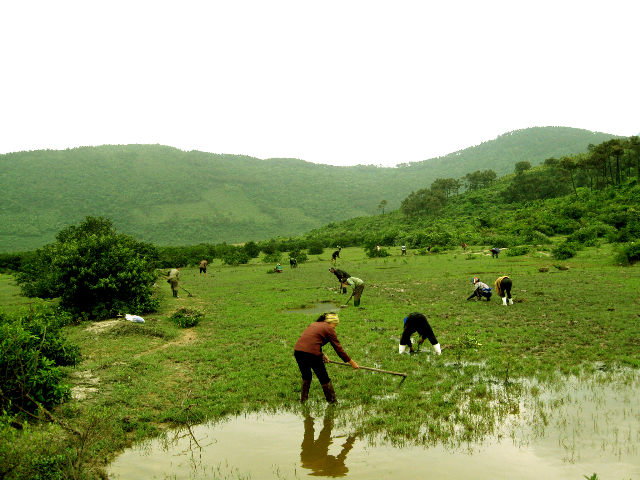
This Community-Based Adaptation project is implemented in two villages: Minh Quy (in an area near the foot of the mountains) and Minh Hue (in a low-lying area near the sea). Despite a high potential for ecotourism, the Ky Nam community is one of the district’s poorest, with 52.5% of households in poverty. Residents are mostly farmers and their income and living conditions highly depend on agricultural activities. Planting rice and gardening with natural water is the main mode of cultivation, while the main agricultural activities are tree crops (groundnuts, beans and peas, sesame), crop plants (wet paddy, potatoes, cassava, oriental basil) and fruit trees (longan, guava, tough custard apple) as well as livestock (cattle and poultry).
A key issue faced by the inhabitants is the poor soil water retention, and the consequent shortage of water for irrigation. The population has to share the Ke Bo dam, the only water storage facility in the entire commune, which has run dry since 2003. Facing a shortage of fresh water and struggling with salinised land due to water intrusion in communities near the sea, people have begun migrating to the South for work. Low productivity and pest damages lead to a decrease in production efficiency, impoverishing households and encouraging poverty and hunger in Ky Nam.
This Community-Based Adaptation project aims at developing the adaptive capacity of the Ky Nam community to mitigate the adverse effects of climate change affecting agricultural production and people’s lives. The project was developed by HUSTA Ha Tinh through a participatory process involving all sectors of the Ky Nam community, and is implemented in partnership with local authorities providing support and assistance. The project tests and demonstrates technologies in agro production to strengthen the preservation and sustainable use of agro biodiversity, land and water resources in order to mitigate adverse effects of droughts and salinisation on the Ky Nam community.
Key Results and Outputs
Objective 1: Enhanced local adaptive capacity and awareness of climate change effects.
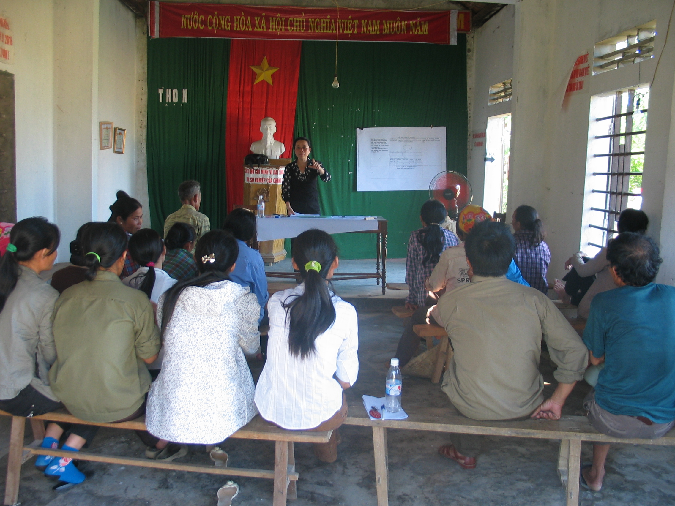
Create/disseminate a project introduction leaflet and 6 billboards (Output 1.1), and hold 3 dialogue workshops for 150 people (Output 1.2) to introduce concepts of climate change and adaptation methods into the community. Incorporate this content into Ky Nam organizations’ operations (Output 1.3).
Objective 2: Two successful models applying agricultural technology to limit drought and saltwater intrusion
Model 1: for communities living in the costal area (addressing drought and salinisation issues) Model 2: for communities living in the upland area (addressing drought issues)
Enhance local capacity to manage agro-biodiversity, including a commune management plan and appropriate community input into the creation of the two models (Output 2.1). Models should ensure that selection of local plants/crops contribute to the prevention of land degradation and incorporate climate change impacts, as well as ensure food security, poverty alleviation, and an increase in income between 15-20%. Build the models in household gardens, to include: forestry plants, fruit trees, herbs, fodder plants, land-covered plants (based on the result of the survey on local plant resources) with 30-45 participating houselholds (10-15ha land); Rice planting land (30-45 participating households, 10,000-15,000 m2 land) (Output 2.2). Establish a model of rainwater harvesting that benefits 15 households in building tanks with a capacity of about 25 cubic meters, sufficient for daily dry season activities. Organize training workshops for 100 participants on water harvesting techniques and their relevance to climate change adaptation (Output 2.3). Enhance local capacity to prevent land degradation and minimize drought impact through 8 training workshops for 400 participants on drought- and salinity-resilient cultivation and varieties. Establish a farmer’s group of interest in climate change adaptation measures in agro production (using land and water sustainably) with the participation of 10-15 households to provide technical assistance and share experiences in applying adaptation measures (Output 2.4).
Objective 3. Monitor and distill lessons learned from the models, share the project results and make recommendations to the local government.
Compile, approve, and disseminate project technical documents on the project models and recommendations (Output 3.1).
Reports and Publications
PIFs
Monitoring and Evaluation
Monitoring and evaluation for community-based adaptation is a new field, and the CBA project is piloting innovative approaches to evaluating the success of locally-driven adaptation projects, and generating lessons to inform ongoing practice.
Key considerations in M&E for CBA include:
- Grounding M&E in the local context: M&E for CBA should avoid overly rigid frameworks, recognizing community heterogeneity and maintaining local relevance
- Capturing global lessons from local projects: CBA projects are highly contextualized, but lessons generated should be relevant to stakeholders globally
- Incorporation of both quantitative and qualitative indicators: to ground projects in tangible changes that can be objectively evaluated, and to capture lessons and case studies for global dissemination
To these ends, the CBA project uses three indicator systems: the Vulnerability Reduction Assessment, the Small Grants Programme Impact Assessment System, and the UNDP Climate Change Adaptation Indicator Framework.
The Vulnerability Reduction Assessment (VRA)
The VRA is a question-based approach with the following aims:
- To make M&E responsive to community priorities
- To use M&E to make projects more accountable to local priorities
- To make M&E capture community ideas and local knowledge
- To gather community-level feedback to guide ongoing project management
- To generate qualitative information
- To capture lessons on specific issues within community-based adaptation
- To generate case studies highlighting adaptation projects
The VRA follows UNDP's Adaptation Policy Framework, and is measured in a series of meetings with local community stakeholders. In these meetings, locally-tailored questions based on standard VRA questions/indicators are posed, and the community assigns a numerical score on a 1-10 scale for each question. Progress is evaluated through changes in scores over the course of implementation, as well as through qualitative data collected in community discussions surrounding the exercise.
UNDP has developed a Users Guide to the VRA (Espanol) (Francais) as a tool to assist practitioners to conceptualize and execute VRA measurements in the context of CBA projects.
The SGP Impact Assessment System (IAS)
The CBA, being a project of the GEF Strategic Priority on Adaptation, aims to increase the resilience of ecosystems and communities to the impacts of climate change, generating global environmental benefits, and increasing their resilience in the face of climate change impacts. To this end, the CBA projects use the SGP's impact assessment system for monitoring achievements in GEF focal areas (focusing primarily on biodiversity and sustainable land management).
The IAS is composed of a number of quantitative indicators which track biophysical ecosystem indicators, as well as policy impact, capacity development and awareness-building.
UNDP Climate Change Adaptation Indicator Framework
CBA projects also track quantitative indicators from UNDP's adaptation indicator framework, corresponding to the thematic area on natural resources management. More information on UNDP's indicator framework can be found on the UNDP climate change adaptation monitoring and evaluation website.
* This description applies to all projects implemented through UNDP's Community-Based Adaptation programme. Specific details on this project's M&E will be included here as they become available. *