CBA Samoa: Sato'alepai
Project Overview
Sato'alepai village, located on the northern coast of Samoa’s Savai'i Island, is working to reduce its vulnerability to flooding events. This Community-Based Adaptation project will help the village build box culverts that enable the free flow of water from the wetlands to the sea, thereby reducing flood risks to agricultural land and homes. This will also help reestablish the natural dynamic equilibrium and health of the wetlands upon which community members rely for their livelihoods. Finally, these structures will provide an escape route to move to higher ground during severe storms. In addition, the project will plant mangroves to help strengthen the wetlands in conjunction with a climate change awareness programme. This project partners with AusAID, which is co-funding project efforts.
* This project is part of UNDP's "Community-Based Adaptation" portfolio. *


Project Details
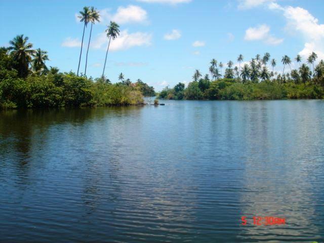
This Community-Based Adaptation project in Samoa reduces the vulnerability of Sato'alepai village, neighbouring villages and the surrounding ecosystems from the impacts of climate change. Sato'alepai village is highly vulnerable to climate change risks such as intensive cyclones, rising seas, and flooding due to its location between the seafront and wetlands. Cyclones and high surging waves affect the front of the village, where in the 1990’s around 30m of the coastline washed away—taking homes along with it. Behind the village is the Sato'alepai wetlands where the intensive rainfall is now causing major flooding problems, spreading into family homes and the community church.
The wetland and marine ecosystems are also affected by climatic changes as more intensive regular waves during high tide result in changing formulations of coral species in the inshore reef. The change in coral formation is also enabling villagers and fisher people to walk on the corals easily, causing die-offs.
The increased flooding in the wetlands and the irregular flow of water between the sea and the wetlands is affecting the use of the wetlands as a nursery ground, increasing siltation in the wetlands, and exacerbating ponding, thus destroying the wetland ecosystem.
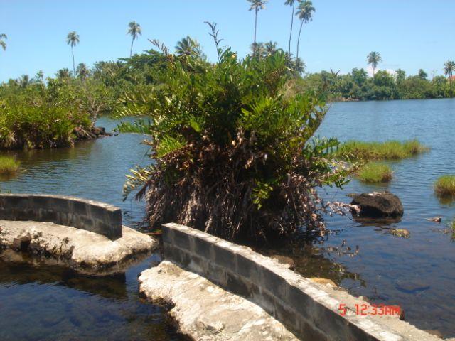
Through efforts by the village and government to reduce vulnerabilities, a seawall was built along the village coastal area, and a village road across the wetland so people could access the inland area. Unfortunately, the access road has limited the flow of water between the two sides of the wetland and contributed to increasing flooding on one side of the village.
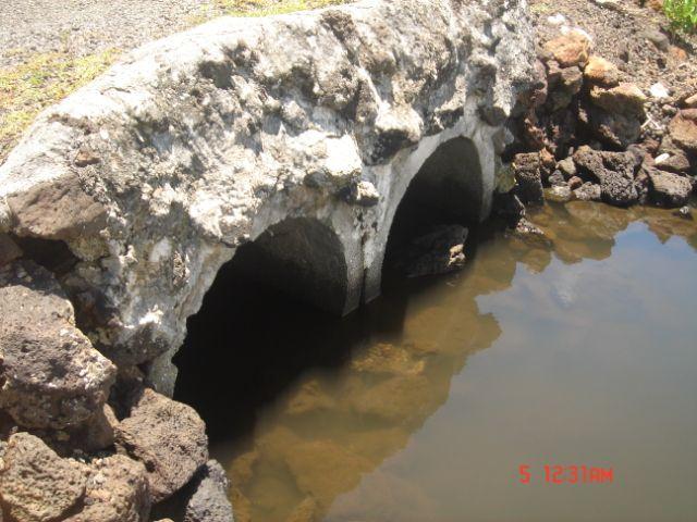
To reduce the vulnerability of Sato'alepai village to cyclones and flooding, this project will build at least three 5-meter box culverts along the road to increase the flow of the water between the wetlands. It will also initiate mangrove and wetland replanting activities to rehabilitate the wetlands.
Key Results and Outputs
Outcome 1.0: Ecosystems increasingly resilient to climate change impacts, and better able to buffer communities against risks of increasingly intense floods, cyclones and storm surges.
Upgrade access road (Output 1.1) and rehabilitate wetland (Output 1.2).
Outcome 2.0: Capacity developed among community members to manage local ecosystems to reduce ongoing climate change risks
Lead an awareness-raising programme (Output 2.1).
The program seeks to achieve the following results:
* Upgrade the village access road with the installation of box culverts to help water flow more freely during heavy flooding. This will help protect the community from increasingly devastating floods and reduce inland migration by farmers;
* Rehabilitate fragile wetlands in the coastal swamp and replant wetland plant species in the mangrove forest to improve ecosystem resiliency;
* Improve water flow within wetlands to help protect homes and farms from flooding and reduce salinization due to from rising sea levels;
* Increase adaptive capacities with a focus on increasing climate change awareness, and improving local resource management practices, including biodiversity protection and adaptive land and coastal management.
Reports and Publications
Brochures, Posters, Communications Products
PIFs
Project Brief / Fact Sheet
Multimedia
Monitoring and Evaluation
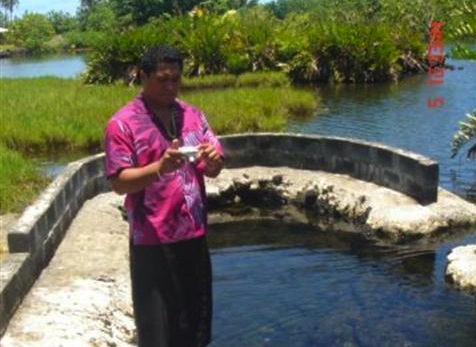
The assessment on the impacts of climate change on the communities started in the development of the CIM Plans in 2007. In these consultations, all sectors of the community were provided with maps of the area, whereby affected areas from climate changed were identified and visited. These consultations identified cyclones, flooding, and coastal erosion as the main climate risks and were seen as extremely damaging noting that the majority of the homes and roads within the village was destroyed. In between the cyclones, the village identified flooding as the most regular climate risk issue with the inland road blocked therefore restricting access to higher grounds for safety.
The VRA analysis information was reviewed in the meeting on the last week of May. In identifying possible options to reduce the climate risks, the village using information already gathered from the CIM Plan, and the VRA process, identified flooding, cyclones and coastal erosion as the main climate risks. The impacts of flooding, cyclones and strong wave surges were identified as safety of people, agricultural crops, livestock, and homes. Environmentally, it was also recognized that the climate risks also impact on the critical ecosystems such as coral reefs, and the wetlands that provide pertinent ecological services that support human.
To reduce the vulnerability to cyclones, flooding and coastal erosion, the main activities agreed upon were the upgrading of the access road so families could easily access the uplands when cyclones, high waves and flooding affect village. This actions was also seen as a way of protecting the wetlands and biodiversity from continued pollution from household activities, waste disposal and feral pigs.
To reduce the vulnerability on the increasing sea level rise, the village agreed to improve the flow of water within the wetlands to reduce salinization of the wetlands and flooding in the village and agricultural plantations.
Other issues identified in the CIM Plan as impacts of climate change included the lack of water supply within the village and district, especially for families that have moved inland from the coast. The new project for the district for upgrading its water supply network has been approved for funding by the European Union. The maintenance of the public roads along the village has now been taken up by the MWTI with the recent tar sealing of the old village access road.
Impact Assessment System
The project will not only be measuring the anticipated changes in the vulnerability of the project site on climate risks as identified in the VRA, it will also be measuring the environmental impact of global environmental benefits. The monitoring program will focus on identifying changes in the wetland and marine environment after the proposed civil works.
As a baseline for the biodiversity impact assessment, the project will put under protection all the endangered bird species in the area by banning shooting within and around the project sites and identify marine species found in the wetland prior and after the civil works. . The proposed mangrove replanting program will also be monitored to see how well it grows along with other wetland species.
In the form of land degradation, it is anticipated that once the civil works have been done, the project will measure through discussions with families if there are any more damage to plantations from flooding or not..
The monitoring will conducted 3 times in the life of the project with the first one at the start, the second one after the initial civil works; with the thirds round 6 months after the civil works or at the end of the project.