CBA Samoa: Adaptation to Flooding and Sea Level rise - Avao, Vaipouli, Salei'a
Project Overview
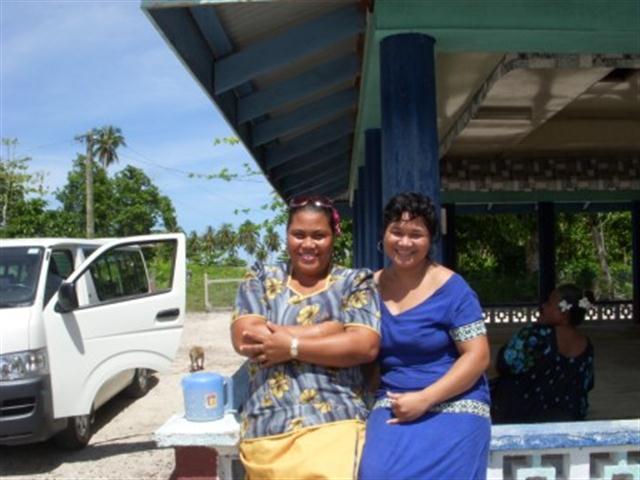
The villages of Salei'a, Avao and Vaipouli lie next to each other in Gagaemauga III District located on the northern most point of the island of Savaii in Samoa. Agriculture and fishing are the main sources of income and livelihood for the villages' 700 inhabitants. The villages front the sea with the two extensive reef breaks approximately 60m from the beach. Over the past 4 years, graves and homes for families have been swept away due to rising level and strong waves.
This Community-Based Adaptation project builds community capacities to provide necessary infrastructure to relieve ecosystem impacts, livelihoods and households from climate risks. To address the flash flooding from the source, the project conducts a replanting program and establishes a water-catchment conservation program to ban deforestation along the stream edges and watershed area. Replanting mangroves and rehabilitating the coastal marshlands provide an important natural filtering system to reduce siltation in the inshore reef that kills corals.
* This project is part of UNDP's "Community-Based Adaptation" portfolio. *


Project Details
This Community-Based Adaptation project focuses on the villages of Salei’a, Avao and Vaipouli in Gagaemauga III District, Samoa. These villages, which contain a population of just over 700 inhabitants, are located on the northernmost point of the island of Savaii. Agriculture and fishing are the main sources of income and livelihood for the villages.
The villages front the sea with the two extensive reef breaks approximately 60m from the beach. The first one directly fronts Avao village and is the location of rapid coastal erosion over the past 10 years where several homes and beach fale tourism development were washed away. A well-constructed seawall now protects the western end of this break, which extends the length of Vaipouli and Salei’a. Behind the old villages of Salei’a and Vaipouli and part of Avao is an extensive wetland formed out of the stream. The stream is the only river system on this northern part of Savaii. This river has an extensive water-catchment and reservoir from which the water system for the district is piped.
The project site is home to threatened ecosystems such as coral reefs, mangrove forest, and mixed herbaceous coastal march which houses some threatened biodiversity as identified in the National Biodiversity Strategy and Action Plan. These include toloa (Anas superciliosa); tolaifatu (Myiagra albiventris); manuma (Ptilinopus perousii); manutagi (Ptilinopus porphyriaceus); and several of the smaller endemic birds. The wetland was once a mixed of mangrove forest and herbaceous coastal marsh, but since the 1990’s, the mangroves have been mostly decimated while the coastal marsh has also diminished. It does perform a fish nursery function for juvenile fish.
Climate change risks for Samoa forecast an increase in average temperature, a rise in sea level, an increase in the intensity of tropical storms and cyclones and a decrease in precipitation, but with more frequent occurences of high intensity rainfall events. Since the 1990’s, climate change impacts such as flooding and coastal erosion have been heavily felt in the project sites. Cyclones Ofa and Val contributed to the erosion of more than 20m of coastline, and affected more than 800m of coastline near these villages. Additionally, all the homes on the seaward side of the main coastal road were destroyed by the storms. Now, these villages only have approximately 100m width of land for residential settlement between the coast and the wetland/stream. The increasing intensity of rainfall has brought regular flash flooding to the area.
This Community-Based Adaptation project aims to reduce the vulnerability of three villages (Avao, Salei’a, Vaipouli) and their ecosystems to the adverse impacts of climate change by building community capacity and providing the necessary infrastructure to protect livelihoods and ecosystems. It was designed through a participatory process involving all sectors of the villages. The project is designed to address both community and ecosystem resiliencies through a mixture of infrastructural and capacity-building activities.
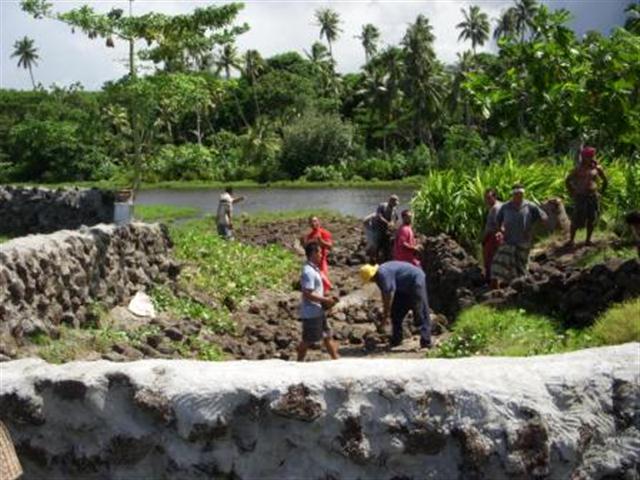
The project will install a rock retaining wall, strengthening vegetation barriers, and clearing the stream pathway. It will also implement a reforestation programme to rehabilitate terrestrial ecosystems. Community capacity for adaptation will be developed through an awareness-raising programme.
Finally, the project proposes to replant mangroves and rehabilitate coastal marshlands, which provide an important natural filtering system needed to reduce siltation of the inshore reef that can kill corals. The retaining wall is not only a way to protect the community against climate risks, but it also allows residents to replant farmland closer to their homes.
Key Results and Outputs
Outcome 1.0: Increased coastal ecosystem resilience to climate change impacts
Instrall rock barriers and clear stream pathway (Output 1.1). Strengthen vegetation barriers (Output 1.2).
Outcome 2: Terrestrial Ecosystems rehabilitated to reduce flooding, water supply shortages, and erosion
Implement reforestation programme (Output 1.1).
Outcome 3.0: Ecosystem management capacities developed among community members
Conduct awareness raising programme on climate change risks and adaptation (Output 3.1). Rehabilitate wetland and stream edge by stopping reclamations using solid waste (Output 3.2).
Reports and Publications
Brochures, Posters, Communications Products
News article
CBA Samoa - Avao/Vaipouli/Salei'a - News Article (Jan. 2011)
PIFs
Project Brief / Fact Sheet
Multimedia
Monitoring and Evaluation
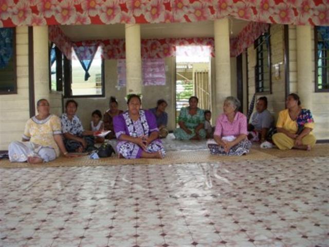
The assessment on the impacts of climate change on the communities started in the development of the CIM Plans in 2007. In these consultations, all sectors of the community were provided with maps of the area, whereby affected areas from climate changed were identified and visited. These consultations identified cyclones, flooding, and coastal erosion as the main climate risks and were seen as extremely damaging noting that the majority of the old village was destroyed. In between the cyclones, the villagers identified flooding as the most regular climate risk issue where homes get flooded and ruined all the time.
The VRA analysis was process undertaken with the village over the last two years, attended by all sectors of the village but in several instances, by mixed group of participants. In the last workshop held April13th 2009, the villages reiterated that rather than again going through the process, they supported all the issues raised in previous consultations.
In identifying possible options to reduce the climate risks, the village using information already gathered from the CIM Plan, again reconfirmed the problems suffered from flash flooding every time there is rain, apart from the extreme high tides and cyclones. Therefore redirecting the stream to one of its old channels that was blocked by sedimentation due to the cyclones, will go a long way in relieving the pressures of flooding.
Another issue supported during the various consultations process including the CIM Plan process is the need to construct a suitable walking bridge for the village to cross over to plantations on the other side of the stream.
Other issues identified in the CIM Plan as impacts of climate change included the lack of water supply within the village and district. The new project for the district for upgrading its water supply network has been approved for funding by the European Union. The maintenance of the public roads along the village has now been taken up by the MWTI with the recent tar sealing of the old village access road.
Impact Assessment System
The project will not only be measuring the anticipated changes in the vulnerability of the project site on climate risks as identified in the VRA, it will also be measuring the environmental impact of global environmental benefits. The monitoring program will focus on identifying changes in the wetland and marine environment after the proposed civil works.
As a baseline for the biodiversity impact assessment, the project will put under protection all the endangered bird species in the area by banning shooting within and around the project sites and identify marine species found in the wetland prior and after the civil works. . The proposed mangrove and reforestation program along with the protected areas to be established.
In the form of land degradation, it is anticipated that once the civil works have been done, the project will measure through discussions with families if there are any more damage to plantations from flooding or not.
The monitoring will conducted 3 times in the life of the project with the first one at the start, the second one after the initial civil works; with the thirds round 6 months after the civil works or at the end of the project.