CBA Samoa: Adaptation to Flooding and Sea Level Rise – Safai Community
Project Overview
Samoa’s Safai village was totally destroyed by the cyclones of 1990 and 1991. Over 80% of the homes located on the coast were decimated by strong winds and surging waves. The wetland ecosystem, the inshore coral reef systems, the mangrove forests, and agricultural lands were all damaged or wiped out altogether. Since so many homes were lost, the majority of families have relocated to customary lands further inland. Despite the movement inland, the Safai village members, their land, and local ecosystems remain vulnerable to climate change impacts. Due to the poor state of their current infrastructure, the community members and their livelihoods are threatened by coastal erosion, flooding, droughts, and sea level rise.
This Community-Based Adaptation project aims to reduce the vulnerability of Safai village and the surrounding ecosystems from the impacts of climate change. By building and improving current infrastructure, the project will allow water to move uninhibited from the wetland to the sea, thus alleviating flooding risks. This will also restore inshore currents, reducing the speed of coastal erosion and improving coastal reef re-growth. Additionally, village land will be protected from coastal erosion through the construction of appropriate wall retentions and the replanting of wetland vegetation.
* This project is part of UNDP's "Community-Based Adaptation" portfolio. *


Project Details
Safa’i village in Samoa is located at the northern most point of Savai’I island. The climate is typical of Samoa, with a rainy season from October to March and a dry season from April to September. The average annual temperature is 26.5˚C. Safai’i is home to threatened ecosystems including coral reefs, mangroves and a coastal marsh. Endangered and endemic species, including over 40 coral species and 60 fish and marine species of significant global importance, are present.
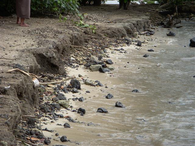
The population consists of approximately 400 people who depend on plantations and fishing as their main sources of income and livelihood. The village fronts the sea with the outer reef approximately 200 meters from the beach. It is therefore highly vulnerable to climate hazards such as flooding, coastal erosion and sea level rise. As a result of two cyclones in the early 1990s, the majority of families relocated inland, away from the coast. In spite of this relocation, the road, some homes, the church, drinking water, agriculture and livestock lands are still affected during heavy rainfall and extreme high sea levels. The wetlands and the coral reef systems work together to maintain ecosystem services. However, with the current infrastructural maladaptations, these systems are being further stressed.
This Community-Based Adaptation project seeks to reduce the vulnerability of Safa’i village and its ecosystems to the impacts of climate change by building community capacities and providing needed infrastructure. It emerges from the Samoan Coastal Infrastructure Management (CIM) plan for the district of Gagaemauga III and was prepared through a participatory process involving all sectors of the village.
As agreed upon during CIM and CBA consultations, the village considered the following activities essential to allow drainage flood waters and to maintain wetland ecosystem services in the face of climate change:
• The deepening of the bridge passage to allow a better flow of the water between the sea and the wetland (CBA leveraged co-financing from the Government of Samoa who will implement this component)
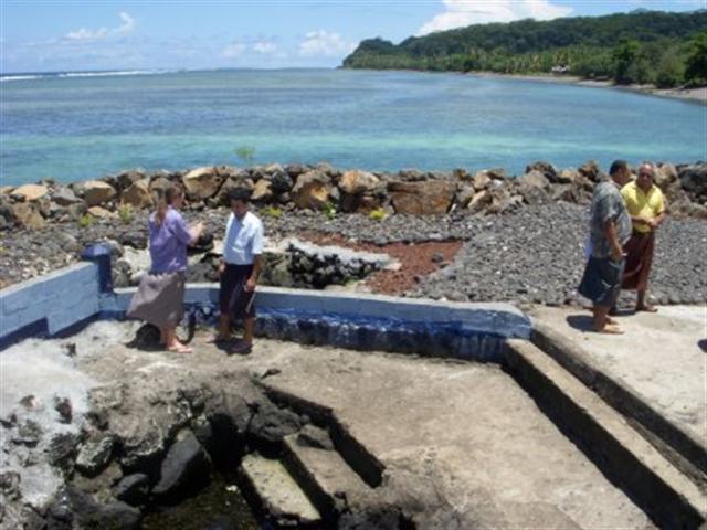
• The construction of a retention wall along the edge of the wetland to reduce the erosion near homes, the church and agricultural land
• The construction of a walking bridge over the wetland that will enable the village to take out the existing rock bridge that is blocking water, fish and other marine organisms from reaching the reef
From an environmental perspective, having a regular flushing of the water allows the wetland to provide its intended services. Seawater flushes in and out with the tides, thus enabling the wetland ecosystem to rehabilitate itself. It also allows an even distribution of sand along the beach as it existed prior to the cyclones. Furthermore, the ability of juvenile fish in accessing the wetlands ensures continued replenishment of the inshore reef fish population. The project also contains a capacity building component that aims at developing the community’s ability to sustainably manage the local ecosystems in order to reduce ongoing climate change risks.
Key Results and Outputs
Outcome 1.0: Increased coastal ecosystem resilience to climate change impacts
Deepen bridge underpass (Output 1.1) and construct retention wall (Output 1.2). Implement wetland revegetation programme (Output 1.3) and restore the flow of water between wetland and sea to allow regular flushing action (Output 1.4).
Outcome 2.0: Capacity developed among community members to manage local ecosystems to reduce ongoing climate change risks
Implement awareness-raising programme (Output 2.1) and prevent wetland pollution through education and training (Output 2.2).
Reports and Publications
Brochures, Posters, Communications Products
PIFs
Multimedia
Monitoring and Evaluation
The assessment on the impacts of climate change on the communities started in the development of the CIM Plans in 2007. In these consultations, all sectors of the community were provided with maps of the area, whereby affected areas from climate changed were identified and visited. These consultations identified cyclones, flooding, and coastal erosion as the main climate risks and were seen as extremely damaging noting that the majority of the old village was destroyed. In between the cyclones, the village identified flooding as the most regular climate risk issue where the inland road to the new homes mostly get blocked, while the stream overflows onto the road, the church and remaining homes along the coast.
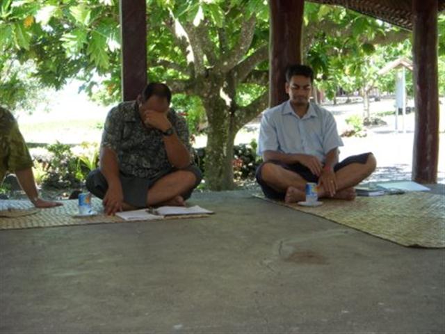
The VRA analysis was process undertaken with the village over the last two years, attended by all sectors of the village but in several instances, by mixed group of participants. In the last workshop held May? 13th 2009, the village reiterated that rather than again going through the process, they supported all the issues raised in previous consultations.
In identifying possible options to reduce the climate risks, the village using information already gathered from the CIM Plan, identified the deepening of the bridge passage to allow for better flow of the water between the sea and the wetland as the most important issue. Additionally, the village also identified the need to strengthen the retention ability on the edge of the wetlands, and specifically the stream linking up with the sea to reduce the erosion of homes and the church. The erosion of the stream edges is also eroding the vegetation on the edge of the wetlands and increase salinization of the mixed swamp vegetation. Therefore having a rockwall with a replanting program along the edge of the wetland is seen as immediate mitigation measures against the lost of vegetation, and reducing erosion along the village.
Another issue supported during the various consultations process including the CIM Plan process is the need to construct a suitable walking bridge for the village. This will allow for the existing rock bridge which is used for crossing to be dismantled thus allowing for better flushing of the water into the sea and movement of fish.
Other issues identified in the CIM Plan as impacts of climate change included the lack of water supply within the village and district, especially for families that have moved inland from the coast. The new project for the district for upgrading its water supply network has been approved for funding by the European Union. The maintenance of the public roads along the village has now been taken up by the MWTI with the recent tar sealing of the old village access road.